History of Amritsar
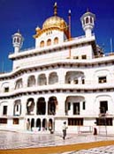 It is here that Akal Takht Sahib (Throne of the Almighty) was revealed by Guru Hargobind Sahib in 1609. Two flags representing temporal and spiritual authority (Sikh sovereignty) have been set up in front of Akal Takht Sahib. Here Guru Hargobind Sahib wore two swords of Miri and Piri (temporal and transcendental authority). The building of Akal Takht Sahib was twice demolished by Afghan armies and was very badly damaged by the Indian regime (in June 1984). The Indian government repaired in in September 1984. The Sikhs began demolishing it on January 26, 1986. The present structure has been constructed by five service-groups headed by Baba Thakar Singh of Bhindran-Mehta Jatha.
On April 13, 1634, the Mogul army attacked Guru Hargobind Sahib here. From 1635 to 1698, Amritsar remained in the control of the Mina family (descendants of Pirthi Chand). During this period, on November 23, 1664, Guru Tegh Bahadur Sahib visited the town. In April 1698, Bhai Mani Singh was appointed as the caretaker of the shrines of Amritsar.
The Mogul chief of Patti tried to occupy Amritsar several times. One such attempt was made in April 1709. The Sikhs, under the command of Bhai Mani Singh and Bhai Tara Singh of Dall-Wan, repelled this attack. When Baba Banda Singh Bahadur occupied several areas in the Punjab, Bhai Mani Singh chose to leave Amritsar in order to avoid the Mogul attacks.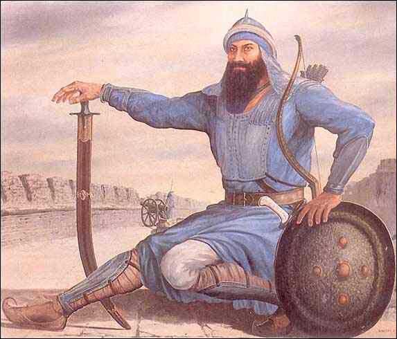
Amritsar Places
Amritsar is one of Punjab´s principal cities, dating back in history over 400 years. It is known more for the world famous Golden Temple, the seat of Sikh religion.Situated on the north-western border of India, the city is also gateway for the travelers on the overland route through Pakistan. The Wagah border, which is the check-post is about 29 kms away. Amritsar literally means "the pool of nectar", the name derived from a pool constructed at the sacred site in the 16th century, gifted by the Mughal Emperor Akbar to Guru Ramdas, the fourth preceptor of the Sikh faith.
Under instructions from Guru Amar Das Sahib, this city was founded by Guru Ram Das Sahib in 1574, on the land bought by him for an amount of rupees 700 from the owners of the village Tung. (Earlier Guru Ram Das Sahib had begun building Santokhsar Sarovar, near erstwhile village of Sultanwind in 1564 {according to one source in 1570}. It could not be completed before 1588). In 1574, Guru Ram Das Sahib built his residence and moved to this place. At that time, it was known as Guru-Da-Chakk. (Later, it came to be known as Chakk Ram Das). Guru Ram Das Sahib began excavation of the Amritsar Sarovar (tank) in 1577. It was ready by 1581. This tank was renovated by Guru Arjun Sahib in 1586. Since then this city is known as Amritsar (after the name of the Sarovar). The foundation of the Darbar Sahib had been laid by Guru Arjan Sahib on January 3, 1588. (Later, it was propagated that the foundation stone of Darbar Sahib was laid by Sain Mian Mir, a Muslim holy man. Sain Mian Mir was very friendly with Guru Sahib but the foundation of Darbar Sahib was laid by Guru Sahib himself). In 1590, Guru Arjan Sahib moved to village Wadali where Guru Hargobind Sahib was born on June 19, 1590. By 1601, the Darbar Sahib was fully ready. In 1603-04, the first volume of Guru Granth Sahib, the Sikh scriptures, was prepared in this city and was installed at Darbar Sahib on August 16, 1604.
It is here that Akal Takht Sahib (Throne of the Almighty) was revealed by Guru Hargobind Sahib in 1609. Two flags representing temporal and spiritual authority (Sikh sovereignty) have been set up in front of Akal Takht Sahib. Here Guru Hargobind Sahib wore two swords of Miri and Piri (temporal and transcendental authority). The building of Akal Takht Sahib was twice demolished by Afghan armies and was very badly damaged by the Indian regime (in June 1984). The Indian government repaired in in September 1984. The Sikhs began demolishing it on January 26, 1986. The present structure has been constructed by five service-groups headed by Baba Thakar Singh of Bhindran-Mehta Jatha.On April 13, 1634, the Mogul army attacked Guru Hargobind Sahib here. From 1635 to 1698, Amritsar remained in the control of the Mina family (descendants of Pirthi Chand). During this period, on November 23, 1664, Guru Tegh Bahadur Sahib visited the town. In April 1698, Bhai Mani Singh was appointed as the caretaker of the shrines of Amritsar.
The Mogul chief of Patti tried to occupy Amritsar several times. One such attempt was made in April 1709. The Sikhs, under the command of Bhai Mani Singh and Bhai Tara Singh of Dall-Wan, repelled this attack. When Baba Banda Singh Bahadur occupied several areas in the Punjab, Bhai Mani Singh chose to leave Amritsar in order to avoid the Mogul attacks.
On December 30, 1711, the Mogul emperor, Bahadur Shah, granted Ajit Singh Palit the charge of Amritsar in order to use him against Baba Banda Singh Bahadur. After the death of Bahadur Shah, Ajit Singh Palit returned to Delhi. In 1721, Bhai Mani Singh returned to Amritsar and re-started regular worship. His first act was to solve a dispute between so-called Tat Khalsa and so-called Bandai Khalsa for the right to the management of the shrines at Amritsar.
On March 29, 1733, a major gathering of the Sikhs was held here in front of Akal Takht Sahib. During the same time a Sarbat Khalsa gathering was also held. It discussed the Mogul offer of Nawab-hood. In April 1734, Bhai Mani Singh was arrested and was martyred at Lahore on June 24, 1734.
 In 1740, Massa Ranghar, a debauched official, desecrated Darbar Sahib. He was punished by Bhai Sukkha Singh and Bhai Mahtab Singh, on August 11, 1740. In 1757 Afghan army demolished Darbar Sahib and Akal Takht Sahib. Baba Dip Singh led several thousand Sikhs against the Afghan. A major battle was fought on November 11, 1757. Baba Dip Singh and several thousand Sikhs embraced martyrdom. Again, in 1762, the Darbar Sahib complex was demolished by Afghan army. On December 1, 1764, the Afghan army made another attack. 30 Sikhs, led by Jathedar Gurbakhsh Singh, fought against mammoth Afghan army and embraced martyrdom. In 1765, the Sikhs began re-construction of the shrines. The central part was ready by 1776. Around 1830, Ranjit Singh gold-plated some part of the inner section of the Darbar Sahib. (It harmed this Sikh institution as some ignorant people began unjustly calling it Golden Temple).
In 1846, the British established themselves in the Lahore Darbar, with a Resident in the Court; and, Amritsar became a place of frequent visits by the British. In order to keep sanctity of the city, H. M. Lawrence, the British Resident, issued an order, dated March 24, 1847, asking the English people to follow the Sikh protocol while visiting the Sikh centres. In 1858, a Municipal Committee was set up here. In 1862, train services between Lahore and Amritsar were started. Khalsa College, the first Sikh college was established here in 1892. [In 1969 Guru Nanak University was established here]. In 1913, the city was electrified. In September 1915, the British declared Amritsar a "Holy City". (This order was undeclaredly annulled after August 15, 1947 by the Indian regime). On April 13, 1919, General Dyer opened fire on the gathering, at Jallianwala Bagh, near Darbar Sahib, killed 379 people and wounded another 1200. The the Shiromani Gurdwara Parbandhak Committee (S.G.P.C.) and the Shiromani Akali Dal were established here in 1920.
On March 29, 1733, a major gathering of the Sikhs was held here in front of Akal Takht Sahib. During the same time a Sarbat Khalsa gathering was also held. It discussed the Mogul offer of Nawab-hood. In April 1734, Bhai Mani Singh was arrested and was martyred at Lahore on June 24, 1734.
In 1740, Massa Ranghar, a debauched official, desecrated Darbar Sahib. He was punished by Bhai Sukkha Singh and Bhai Mahtab Singh, on August 11, 1740. In 1757 Afghan army demolished Darbar Sahib and Akal Takht Sahib. Baba Dip Singh led several thousand Sikhs against the Afghan. A major battle was fought on November 11, 1757. Baba Dip Singh and several thousand Sikhs embraced martyrdom. Again, in 1762, the Darbar Sahib complex was demolished by Afghan army. On December 1, 1764, the Afghan army made another attack. 30 Sikhs, led by Jathedar Gurbakhsh Singh, fought against mammoth Afghan army and embraced martyrdom. In 1765, the Sikhs began re-construction of the shrines. The central part was ready by 1776. Around 1830, Ranjit Singh gold-plated some part of the inner section of the Darbar Sahib. (It harmed this Sikh institution as some ignorant people began unjustly calling it Golden Temple).In 1846, the British established themselves in the Lahore Darbar, with a Resident in the Court; and, Amritsar became a place of frequent visits by the British. In order to keep sanctity of the city, H. M. Lawrence, the British Resident, issued an order, dated March 24, 1847, asking the English people to follow the Sikh protocol while visiting the Sikh centres. In 1858, a Municipal Committee was set up here. In 1862, train services between Lahore and Amritsar were started. Khalsa College, the first Sikh college was established here in 1892. [In 1969 Guru Nanak University was established here]. In 1913, the city was electrified. In September 1915, the British declared Amritsar a "Holy City". (This order was undeclaredly annulled after August 15, 1947 by the Indian regime). On April 13, 1919, General Dyer opened fire on the gathering, at Jallianwala Bagh, near Darbar Sahib, killed 379 people and wounded another 1200. The the Shiromani Gurdwara Parbandhak Committee (S.G.P.C.) and the Shiromani Akali Dal were established here in 1920.
Amritsar Places
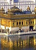
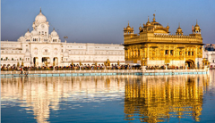 Also known as Harminder Sahib, it is the most revered shrine of the Sikhs. The name Golden Temple originated as the sanctum sanctorum Akal Takht has its roof covered with pure gold plates. The Sikhs from all over the world come to visit the shrine at least once in their lifetime. The four gates in four cardinal directions are an open invitation to all to visit the shrine. The Central Sikh Museum is atop the Clock Tower. The 'Guru Ka Langar' offers free food to around 20,000 people everyday. The number shoots up to 100,000 on special occasions. A visitor must cover his / her head before entering the temple premises. The Granth Sahib is kept in the Temple during the day and is kept in the Akal Takht or Eternal Throne in the night. The Akal Takht also houses the ancient weapons used by the Sikh warriors. Guru Hargobind established it. The rugged old Jubi Tree in the north west corner of the compound is believed to possess special powers. It was planted 450 years ago, by the Golden Temple's first high priest, Baba Buddha. Guru-ka-Langar or the communal canteen is towards the eastern entrance of the temple complex, and it provides free food to all visitors, regardless of colour, creed, caste or gender. Visitors to the Golden Temple must remove their shoes and cover their heads before entering the temple. The temple is less crowded in the early mornings on weekend Also known as Harminder Sahib, it is the most revered shrine of the Sikhs. The name Golden Temple originated as the sanctum sanctorum Akal Takht has its roof covered with pure gold plates. The Sikhs from all over the world come to visit the shrine at least once in their lifetime. The four gates in four cardinal directions are an open invitation to all to visit the shrine. The Central Sikh Museum is atop the Clock Tower. The 'Guru Ka Langar' offers free food to around 20,000 people everyday. The number shoots up to 100,000 on special occasions. A visitor must cover his / her head before entering the temple premises. The Granth Sahib is kept in the Temple during the day and is kept in the Akal Takht or Eternal Throne in the night. The Akal Takht also houses the ancient weapons used by the Sikh warriors. Guru Hargobind established it. The rugged old Jubi Tree in the north west corner of the compound is believed to possess special powers. It was planted 450 years ago, by the Golden Temple's first high priest, Baba Buddha. Guru-ka-Langar or the communal canteen is towards the eastern entrance of the temple complex, and it provides free food to all visitors, regardless of colour, creed, caste or gender. Visitors to the Golden Temple must remove their shoes and cover their heads before entering the temple. The temple is less crowded in the early mornings on weekend | ||
| :: Jallian Wala Bagh | ||
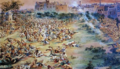 It gained its place in the annals of the Indian freedom struggle when British General Reginald Dyer mercilessly gunned down hundreds of innocent men, women and children who had gathered in the park on the day of Baisakhi in 1919. The park symbolizes the atrocities committed by the British on the Indian soil. It gained its place in the annals of the Indian freedom struggle when British General Reginald Dyer mercilessly gunned down hundreds of innocent men, women and children who had gathered in the park on the day of Baisakhi in 1919. The park symbolizes the atrocities committed by the British on the Indian soil. | ||
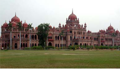 Khalsa College, Amritsar. The oldest college of Amritsar was established in distinctive mix of Mughal and Sikh architecture in the year 1892 by the Singh Sabha Movement. The college campus is spread over more that 300 acres and has that distinctive charm with red minarets and domes against the lush green backdrop. Khalsa College, Amritsar. The oldest college of Amritsar was established in distinctive mix of Mughal and Sikh architecture in the year 1892 by the Singh Sabha Movement. The college campus is spread over more that 300 acres and has that distinctive charm with red minarets and domes against the lush green backdrop. | ||
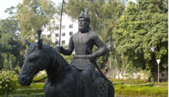
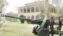 The fort was constructed by Maharaja Ranjit Singh in the early 18th century. The construction and design of the fort was to defend against the attacks of the Afghans. The fort is not open to public now. It has been taken over by the Indian security forces. The fort was constructed by Maharaja Ranjit Singh in the early 18th century. The construction and design of the fort was to defend against the attacks of the Afghans. The fort is not open to public now. It has been taken over by the Indian security forces. | ||
 Built in the third decade of the 20th Century it echoes, not the traditional Hindu temple architecture, but that of the Golden Temple and, in a similar manner rises from the midst of a tank and has canopies and the central dome in the style of the Sikh temple. One of the greatest reformers and political leaders of resurgent India, Pandit Madan Mohan Malviya, laid its foundation stone. It is a well-known repository of Hindu scriptures. The complex houses Shree Laxmi Narayan Mandir with a huge pond on its periphery. The water of River Ravi was diverted to fill it up. In the night the Temple lights shimmering in the water present a heavenly sight. Built in the third decade of the 20th Century it echoes, not the traditional Hindu temple architecture, but that of the Golden Temple and, in a similar manner rises from the midst of a tank and has canopies and the central dome in the style of the Sikh temple. One of the greatest reformers and political leaders of resurgent India, Pandit Madan Mohan Malviya, laid its foundation stone. It is a well-known repository of Hindu scriptures. The complex houses Shree Laxmi Narayan Mandir with a huge pond on its periphery. The water of River Ravi was diverted to fill it up. In the night the Temple lights shimmering in the water present a heavenly sight. | ||
:: Ram Bagh | ||
 The landscaped garden with Summer palace of Maharaja Ranjit Singh in the center. The Maharaja later named it Ram Bagh. It has a museum with relics of Mughal era and hand drawn sketches and portraits of the ruling Sikhs. The landscaped garden with Summer palace of Maharaja Ranjit Singh in the center. The Maharaja later named it Ram Bagh. It has a museum with relics of Mughal era and hand drawn sketches and portraits of the ruling Sikhs. | ||
:: Mata Mandir | ||
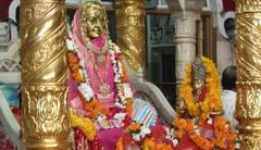 This is the temple built by a devotee of Mata Vaishno Devi. The temple is must visit shrine for all the Hindus visiting Amritsar. This is the temple built by a devotee of Mata Vaishno Devi. The temple is must visit shrine for all the Hindus visiting Amritsar. | ||
 Ram Tirath Temple is located at a distance of 11 KM from Amritsar. The temple dates back top the period of Ramayana. There is an ancient tank at this place. At the site there is a hut where Mata sita gave birth to Luv and Kush. The site also has Maharishi Valmiki’s hermitage and a well with stairs where Mata Sita used to take her bath. The Temples exhibit scenes from Ramayana. Ram Tirath Temple is located at a distance of 11 KM from Amritsar. The temple dates back top the period of Ramayana. There is an ancient tank at this place. At the site there is a hut where Mata sita gave birth to Luv and Kush. The site also has Maharishi Valmiki’s hermitage and a well with stairs where Mata Sita used to take her bath. The Temples exhibit scenes from Ramayana. | ||
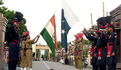 Attari Border about 28 kms. from Amritsar is the oldest border crossing between India and Pakistan. It’s an interesting experience especially at sunset when the 'Retreat' ceremony takes place with the BSF on the Indian Side of the Border. The daily highlight is the evening "Beating the Retreat" ceremony. Soldiers from both countries march in perfect drill, going through the steps of bringing down their respective national flags. As the sun goes down, nationalistic fervors rises and lights are switched on marking the end of the day amidst thunderous applause. Attari Border about 28 kms. from Amritsar is the oldest border crossing between India and Pakistan. It’s an interesting experience especially at sunset when the 'Retreat' ceremony takes place with the BSF on the Indian Side of the Border. The daily highlight is the evening "Beating the Retreat" ceremony. Soldiers from both countries march in perfect drill, going through the steps of bringing down their respective national flags. As the sun goes down, nationalistic fervors rises and lights are switched on marking the end of the day amidst thunderous applause. | ||
 In 1982, Harike Pattan was officially declared a bird sanctuary. In 1982, Harike Pattan was officially declared a bird sanctuary.In 1992 It has been identified as one of the sites for conservation under the Indian National Wetland Programme. Harike Pattan is today a vital staging post and winter home to waterfowl, including some globally threatened species. Spread over 93 square miles, Harike wetland in Punjab’s Taran Taran District is the second largest bird sanctuary of India. It’s home to rare varieties of avifauna arriving here from different parts of Europe and northern Asia for stay during a major part of the year. Throughout the year, autumn, spring and winter, Harike Pattan becomes a refuge to over 361 species of birds, 140 of who believed to breed here. Some of the birds that can be spotted are the Cotton Pygmy Goose, Tifted Duck, Yellow crowned Woodpecker, Yellow eyed Pigeon, Watercock, Pallas's Gull, Brown headed Gull , Black headed Gull, Yellow legged Gull, Indian Skimmer, White winged Tern, White rumped Vulture, Hen Harrier, Eurasian Sparrow hawk, Eurasian Hobby, Horned Grebe, Black necked Grebe, Great Crested Grebe, White browed Fantail, Brown Shrike, Common Wood shrike, White tailed Stonechat, White crowned Penduline Tit, Rufous vented Prinia, Striated Grass bird, Cetti's Bush Warbler , the Sulphur bellied Warbler and Diving duck etc . The sanctuary is home to the endangered Testudine Turtle and Smooth Indian Otter listed in the IUCN ( The International Union for the Conservation of Nature and Natural Resources) Red list of Threatened Animals. Harike is also well known for its market for sweet water fish. The sanctuary came into existence with the construction of a barrage at the confluence of the river Beas and Satluj for water storage and providing irrigation and drinking water. Best Time To Visit : Between November and March How to Reach There : The nearest railway station and airport are both at Amritsar ( 60 km away) Places To Stay : There are any number of government approved hotels at Amritsar. |
 the octroi on the merchandise passing through his territory of the G.T. road, he constructed the Qila. The present Qila is divided into two parts- one, the Qila Androon, the interior portion, was built by Ala Singh. Situated on a mound, it ascends as one moves into it. While the other i.e., between the Qila Androon and outer walls with the secretariat on the left and Darbar Hall on the right, was built by Maharaja Karam Singh. The Darbar Hall is now converted into a mini museum where rare arms and armours including a sword of Nadir Shah known as 'Shikar Gah' are on display. Most precious pieces of art are the rich collection of tree-like chandeliers made of Bohemian cut-glass emitting prism like radiant splendour and sheen. To those interested in metallurgy and guns, a visit to the Cannon Park within the premises of the Qila Mubarak would certainly be a thrilling experience of life time. The murals inside the palaces are rare specimen of the Kangra and Rajasthan paintings.
 Sheesh Mahal and beautiful garden. It is a four storeyed structure with massive stone-walls, arched openings, filtered and ornamental grills and crowning domes.
 The interior casts a Kaleidoscope phantasmagoria of myriad images and multi-coloured lights. The museum has a rich collection of miniature paintings of the middle of 19th century. Themes of these paintings are based on the Geet Gobinda or Jaya Deva's poetry. The Kangra paintings depicting the, Krishan Lila reflect the highest professional and delicate taste. Paintings displaying the Raga-mala of the Rajasthan schools and that of the Mughal give a visual meaning to the Ragas.
 Mahendra Singh was a great patron of modern education. He established this college in 1870 for the people of Patiala. Its building is a wonderful piece of architecture. Famous for its architectural excellence, the institution for a long time was the only one between Delhi and Lahore. Serving as a major institution of higher education, many students from neighbouring states and as far as Delhi used to come to Patiala for receiving education.
 Prince brought all kinds of saplings of rare trees and planted them here in the garden. The huge fruit trees, the Fern House and the Rock Garden stand testimony to his interest. The Baradari Palace now houses the Punjab State Archives, a repository of rare documents of historical importance.
 As the tradition goes, Nawab Saif Khan was a great admirer of Guru Teg Bahadur. He invited him to spend rainy season here. His visit is commemorated by two gurdwaras- One inside the fort and the other outside across the road. It is famous as Panj Bali Gurdwara.The Bahadurgarh Fort was constructed by Maharaja Karam Singh during 1837-45 at a cost of Rs. 10, 00,000. Its circumference is one mile, 536 yards and 2 feet.